
- by Alison
Fight Dengue app: tackling dengue at the source
Data on where people have been in the days leading up to their diagnosis promises to provide a novel source of insight on the source of infections. But accessing that data isn’t as easy as you might expect, as the Fight Dengue app’s creator explains.
“If there’s a mosquito outbreak near where we live, I want to know so I can ensure my kids put on extra protection before they go to school,” says Steve Barnes, CEO of Access Devices Asia and inventor of the Fight Dengue application.
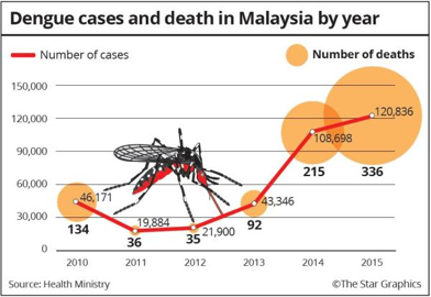 Steve and his family live in Malaysia, where dengue cases and deaths have been growing year on year. “So much more could be done,” says Steve. “People don’t understand that they need to be quarantined for a week if they’re infected. A lot more education is needed.”
Working in IT, Steve is more than familiar with the term Big Data and how the technology giants are gathering loads of data to build a big picture of the world around us. But Steve wasn’t interested in the big picture; he just wanted to know about the things that are important to him.
“I’m not interested in the broad brush strokes,” says Steve. “I want to know where dengue is and where it has come from so I can protect my family.”
Unable to find a tool that would let him know when there was mosquito activity nearby; Steve decided to develop his own web app: Fight Dengue.
Combining official and informal data sources
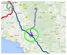
Steve’s Fight Dengue app marks active dengue cases with red spots, then uses green heat maps to mark bites and blue heat maps to mark breeding grounds.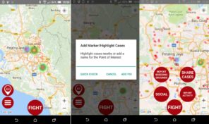
Case information is sourced from official case data feeds supplied by the Ministries of Health of Malaysia and Singapore. Information on mosquito activity and breeding grounds are crowdsourced: users use the app to report breeding grounds or bites. Users can also use the app to check on dengue and mosquito activity in their local area and to share local cases on social media.
“The app lets people know whether their area is safe or if they need to take extra precautions because there is a dengue outbreak nearby,” say Steve. “I use it to see if there are cases near my home and my kids’ school.”
To date, more than a thousand users have downloaded the app.
But knowing where the dengue cases and mosquitos are is only half the battle.
Where’s the source of infection?
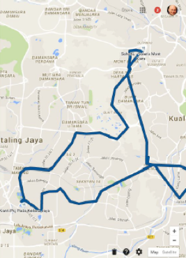
“We also need to know where people are being infected,” adds Steve. “Three of his wife’s school friends were diagnosed with dengue a few days after meeting in the park. There’s a high chance that the park was the dengue source.”
Combining accurate data on the locations of each infected person in the days preceding diagnosis could help to identify potential sources of infection; it could be overlaid to identify common locations.
“If we know where the infection started then we can narrow down the sources of dengue,” says Steve. “Identifying the source of infection will have a dramatic effect on the number of future cases. It doesn’t require a huge amount of data or processing power.”
Steve would like to see doctors ask their patients to install the Fight Dengue app and anonymously submit data on where they’ve been for the last 15 days at the point of diagnosis. There are a number of different ways this could be done:
- By using the app to collect the data on where a person goes and upload the information if they become infected. For that to work, everybody would need to install the app in case they become infected.
- By using location data gathered by an infected person’s mobile service provider as the source of where they have been, but that lacks accuracy and there’s much red tape to cut through.
- By using location data gathered by Google but, although Google probably has much of the data needed, it doesn’t provide an easily usable API (programming interface) that would allow Steve to do this.
“When someone is diagnosed with dengue, we could immediately compare the previous location data of this patient,” says Steve. “If we could locate the source of the infection, resources could be used more effectively to resolve the problem.”
For now, without that all-important local data, Steve simply plans to simply keep the app running and, whenever there is mosquito of dengue activity near to where he lives, to ensure his family is adequately protected and print off the map and share a copy with local schools.
Meanwhile, our Dengue Track here at Break Dengue has also been crowdsourcing dengue data and translating it into meaningful and actionable information, alerting people when they may be at risk. “I think it’s a great tool,” comments Steve. “It has a nice novel way of crowdsourcing additional data from the users and a huge selection of educational material, which is so valuable.”
With so much data being gathered, how are you using the figures to help your local fight against dengue?